By Leslie Bull
Staff Writer
For the past 35 years, Kachnovich Land Surveying, Inc. has been
helping the landowners of western Maine establish their property
boundaries. According to founder James Kachnovich, a licensed, professional
land surveyor (p.l.s.), a lot has changed over the past three decades
in the technology end of the business, but the reasons for having
a survey done are pretty much the same. If you own property that
hasn't been officially surveyed, you could be in for some unpleasant
surprises such as:
- You just spent a small fortune on the swimming pool of your dreams,
only to discover that the deep end is poking five feet into your
neighbor's property.
- You honestly believe that the timber you've
been harvesting for firewood was from land your family has owned
for decades, but it's actu ally from land owned by your new neighbor
from Massachusetts.
- The land-locked property directly behind yours
finally gets sold and the new owner's right-of- way runs straight
through the middle of your thriving vegetable garden.
- You built
a charming cabin with a glorious view of the lake from the front
porch, and you receive notice that it's fifty feet too close
to the water according to town zoning regulations.
 All four of these unfortunate scenarios and similar ones can be
avoided with a land survey. All four of these unfortunate scenarios and similar ones can be
avoided with a land survey.
"Most people assume that the land they own is clearly defined
in the deed," said Toby Kachnovich, p.l.s., James' son who also
works for the company.
In reality, if the boundaries of your property have not been officially
determined by a licensed surveyor, there is no guarantee that your
acreage is correct. It often comes in the form of an unpleasant surprise
to many landowners that mortgage inspections and clear titles are
not adequate substitutes for a land survey.
"Even if you are not planning on building anything new, there
are many ways a land survey can help you, and it will definitely
add value to your property," Toby said.
Toby noted a recent incident where the sale of a local home fell
through solely due to the lack of an official land survey. Unfortunately
for the seller, the prospective buyer didn't feel comfortable purchasing
the home without knowing ahead of time what the true property boundaries
were.
As they say, "knowledge is power", and a land survey provides
a wealth of knowledge about the property you own.
What exactly is a land survey? If you've never experienced an immediate
need to have one done, you may not know what's involved.
 Russell Roy, a Jay native who joined the Kachnovich surveying team
in 2004, explained, "There's a lot more to land surveying than
most people realize. Clients tend to only see us working in the'field
on their projects, but what is not often recognized are the hours
and days of research at the town offices, Registry of Deeds, Registry
of Probate and the Highway Department. Basically, we're searching
for historical records relating to the land in question and often
the land surrounding it, and at least 50% of the time spent on a
land survey is tied to this research." Russell Roy, a Jay native who joined the Kachnovich surveying team
in 2004, explained, "There's a lot more to land surveying than
most people realize. Clients tend to only see us working in the'field
on their projects, but what is not often recognized are the hours
and days of research at the town offices, Registry of Deeds, Registry
of Probate and the Highway Department. Basically, we're searching
for historical records relating to the land in question and often
the land surrounding it, and at least 50% of the time spent on a
land survey is tied to this research."
Many boundary searches are far from cut and dried. Some properties,
especially ones dating back a century or more, have original deeds
that can seem almost cryptic, containing language along the lines
of, "from the stone wall at the South corner of the Smith's
property to the Shady Creek's East bank near the waterfall," etc.
Whether or not that stone wall still exists, or even if the Smiths
still own the property next to yours, a surveyor would need to research
both properties as far back as possible to ensure the most accurate
boundary line. If five separate property owners have land touching
yours, the surveyor may have to do extensive research on all five
properties.
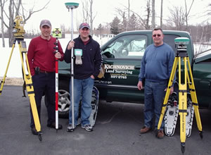
James notes that technological advancements in equipment have made
the actual field work much easier than it was 35 years ago, when
measurements had to be done with hand tape and a compass. The company's
newer equipment such as the Electronic Total Station and recently
acquired RTK GPS System can cover more distance with greater accuracy.
The Electronic Total Station takes measurements with a laser that
can reach up to 9,000 feet, and the RTK (Real Time Kinematic) GPS
system, which is considerably more technical and precise than a standard,
hand-held GPS device, can pinpoint property boundaries down to the
closest centimeter.
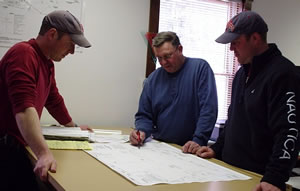
Technological advancements have occurred in the mapping process
as well. James explained, "After all of the research and field
work on a project are done, we use the information we gathered to
make a detailed property map. We used to have to do it all by hand,
but special computer programs have made it possible to produce a
higher quality map. It's easier to read and it looks nicer, too."
Toby said, "The map will show the official property lines and
any other points of interest the landowner should be aware of, like
right-of-ways, zoning issues and any areas of land that aren't suitable
to build on due to marshy or otherwise unstable conditions."
Of course, it's hard to be in business for 35 years without at least
one good story. James, Toby and Russ have all experienced occasional
brushes with nature, from angry hornets to a curious moose or two,
but many years ago James almost backed into a bear.
"It happened back in the tape and compass days, when you'd
drag the tape along the ground from point to point, through all sorts
of brush and vegetation," James recalled. "I
was dragging the tape through some wild blueberry bushes and almost
backed into a bear. Bears really like those blueberries, and we definitely
surprised each other. I think the bear was more scared of me than
I was of him-- they really don't like peo ple very much-- and he
ran away immediately."
|